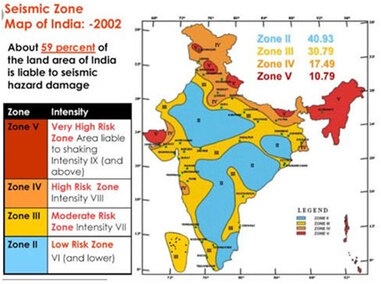
In the field of seismology, seismic zones are, areas divided based on the frequency and intensity of expected earthquake. Indian subcontinent comprises of four seismic zones those are- II, III, IV and V. These zones are categorized based on scientific research related to seismicity and earthquake occurrence in the past years.
Earlier India was divided into five zones, but then, The Bureau of Indian Standards [IS 1893 (Part I):2002] decided to group the country into four seismic zones, where, the first and second zone being unified.
The Bureau of Indian Standards is responsible for publishing seismic activities in terms of seismic hazard maps and codes. They brought out a total of three versions of seismic zones; a six zone map in 1962, a seven zone map in 1966 and a five zone map in 1970/1984.
Seismic Active Zone:
Seismic Zone II: This is the area that suffers least damage of the other three zones. Intensity of earthquake lies between intensities V to VI of MM scale (MM – Modified Mercalli Intensity scale).
Zone II covers those areas which are not covered by the other zones listed below.
Seismic Zone III: Zone III receives moderate damage. This damage corresponds to intensity VII of MM scale.
States that lie under this zone are- Tamil Nadu, Orissa, Andhra Pradesh, Maharashtra, Chhattisgarh, Bihar, Jharkhand, Bihar, Madhya Pradesh, Kerala, Gujarat, Goa, Lakshadweep islands, West Bengal, Karnataka, parts of Punjab and some remaining parts of Uttar Pradesh.
Read more
~~~~~~~~~~~~~~~~~~~~~~~~~~
Published By
Arka Roy
www.constructioncost.co
~~~~~~~~~~~~~~~~~~~~~~~~~~
Published By
Arka Roy
www.constructioncost.co
~~~~~~~~~~~~~~~~~~~~~~~~~~


 RSS Feed
